Posted:


Editor's note: Today’s guest blogger is Steve Alexander, Creative Director of E-commerce for Amtrak, the United States’ intercity passenger rail service and high-speed rail operator. See what other organizations that have gone Google have to say.


Rail travel has been around since the mid-1800’s, but these days at Amtrak, we spend more time looking forward than backward. A big part of being innovative and making travel easier for our 31 million passengers every year, is giving people accurate information about train locations and arrival times. Google Maps Engine is providing the technology behind our newest online feature: an interactive train locator map that makes it easy for people to see where trains are and when they’re getting to their destinations.

Checking on train status is the second most-common activity at Amtrak.com, right after buying tickets. Whether it’s a business traveler trying to figure out which train to take to get to a meeting on time, or a parent wanting to know when to pick up their kid returning from college, everyone wants to know when their train will arrive. Prior to the train locator map, Amtrak customers could only see a text list of train status and station arrival times. The station map we launched for our customers last year had already shown us how compelling a visual representation of train information could be – and that led us to expand our use of Google Maps Engine for our latest map.

Our new train locator map lets people look at all the active trains across the country, or zoom in on a given region or station. People can search for one of our 300 daily trains by name or train number. By mousing over a train on the map, they can see a pop-up window showing whether the train is on time or late, and when it’s going to arrive at the next station. We get the near real-time data from GPS devices on each of our trains; as a train passes by sensors near the tracks, the location information is pushed into Google Maps Engine, along with station data from our content management system.


With Google Maps Engine, the map data is in the cloud, so we don’t have to host and maintain the infrastructure. It provides us with a reliable platform and a comprehensive basemap so our E-commerce team can focus all our energy on building useful maps that will help our customers.

This way, Amtrak can continue to think up more ways to make our map traveler-friendly, like adding information about local transit, restaurants and nearby tourist attractions. As we build more layers on top of the map, we hope it improves the customer experience even further and changes the way our customers think about their upcoming travel with us.

Posted:
Editor's note: Our guest blogger today is Dan Shearer, Director of Safety of SeaPort Airlines Inc., a regional commuter airline operating flights to 21 destinations across 9 states. See what other organizations that have gone Google have to say.

Planes are a way of life in the rugged inlets of Southeast Alaska. While cars and roads rule the terrain in the lower 48 states, flying is often the easiest way to get around the mountains, moose and water that dominate the North. SeaPort Airlines Inc. was born in these rugged outdoors -- we’ve been flying short routes in and around Juneau, Alaska since 1982, back when the company went by Wings of Alaska -- and have since added commuter routes in Oregon, Southern California and six states in the Midwest and South. Altogether, our staff of approximately 225 is spread out across the country and operates a fleet of 20 planes.
You can’t underestimate the importance of communication in the aviation world. Everyone has to be on the same page at all times, so we can accurately communicate weather reports, passenger lists, flight times and other critical information. For years, we did this on paper, by emailing attached spreadsheets or using an outside file-sharing service. While we were meticulous in our method, there was always the risk of grabbing an out-of-date document with incorrect details. We implemented two or three different hosted email systems over a four year period, but none of them lived up to our expectations; we faced ongoing problems with outages, lost emails and not enough storage.

We knew we needed a more stable and collaborative platform. With help from Google Apps Reseller ViWo, we switched to Google Apps in January. ViWo was instrumental in getting us up and running. They showed us the best way to roll out and set up Apps to our 225 employees, pointed out tools for transferring data and helped with ad hoc technical support.

With Google Apps, we got a reliable email system with built-in collaboration tools that all our employees can access with a single login. Best of all, it was easy to use. It took me just a few hours one night to create a Google Sheet that’s become the main way we track our departure and arrival status and performance to make sure our flights are running on time and scheduled efficiently. Dozens of agents can update the master Sheet at the same time without us worrying about losing any data or getting a detail wrong. Sheets even translates time zones and lets us easily process monthly reports. We also use Google Docs for internal information like reservation instructions and contracts. We can update these details instantly for the whole company, without printing off hundreds of new pieces of paper.

In the past, IT was best described as reactive, and our technology problems took valuable time and energy away from our primary focus: delivering customers and their baggage safely and on-time to their destinations. Google Apps is changing that. Now, it’s simply a matter of people getting more comfortable with using the system. Just like flying in Alaska, IT managers know they’re going to run into pockets of turbulence. Google Apps ensures that at least our email and collaboration experience is a smooth ride.

Posted:


Editor's note: Our guest blogger this week is Alberto Herrasti, Consulting Director of Digital Government Projects at the Secretaría de la Función Pública (Secretary of Public Administration, SFP) from the government in Mexico. See what other organizations that have gone Google have to say and discover our interactive demos.

As the Consulting Director of Digital Government Projects of SFP, I work to bring tools that make information easily accessible to Mexican citizens. We recently deployed Google Earth and Google Maps to solve a long-standing problem.

In the past, both our local population and our government workers had trouble finding official documents and records about government agencies and services because this information was distributed across various websites in a fragmented way.

Finding something as simple as the opening hours of a state-owned gas station, or the location and address of a nearby hospital would require a search across many official sites. The only alternative would be to physically visit the offices likely to have the information and spend more time waiting in long queues.

In 2010, the President’s office directed us to address this problem, and we set out to create a consolidated website (now known as mapas.gob.mx) that would serve as a central repository of geo-indexed data, allowing citizens to easily retrieve up-to-date information overlaid on the map data of Mexico.

We reached out to a number of mapping technology providers to evaluate their offerings but the Instituto Nacional de Estadística y Geografía (INEGI) -- Mexico's offical mapping and statistics institution -- identified Google Earth and Google Maps as our best option. We completed and launched the new site by 2012. The site integrates data from more than 70 public organizations and aims to place useful and helpful information in the hands of our local population.

Now, with the new Google Maps-integrated site, any user can find information by viewing it on a familiar, easy-to-navigate “globe”. We’ve also added a lot of useful information. The site now consolidates more than 900 maps with government-related information and covers every region of Mexico. As of 2013, more than 300 people use the site daily, and both awareness and use continues to grow rapidly. Instead of waiting in long lines or spending hours searching online, citizens can simply point their browsers to the new site and use maps to quickly find nearby resources and information.

Since we launched the tool in 2012, we’ve had more than 16,150 downloads of the geolocalized data and this tool allows government agencies to respond more effectively and efficiently. Thanks to the Google Earth and Google Maps technology which made the tool easy to build and easy to use, we’re able to better serve our citizens and respond to their needs with the right information at the right time.


Posted:


When it’s raining out, do people’s shopping habits change? Those are the kind of questions the team at Interactions Marketing, working with Tableau Software, think about when analyzing massive data sets on behalf of retailers. In a highly competitive market, retailers need the edge they can gain from business data – and with the analysis they can generate using Google BigQuery. By analyzing these data sets, you can find what Interactions Marketing calls “unexpected insights,” which help businesses make predictions that can improve sales. For example, they look at how external factors like the weather will affect retail sales.

Find out more about the value of Big Data and unexpected insights for retailers – and how Google BigQuery supports these analytics projects – in our Hangout On Air on Thursday, September 26, at 9 a.m. PT. Giovanni DeMeo, Vice President of Global Marketing and Analytics for Interactions Marketing; Paul Lilford, Global Director for Technology Partners at Tableau Software; and Daniel Powers, Director of Sales for Google Cloud Platform will explain how retailers can understand their businesses better and boost success:

  • How can unexpected insights help retailers attract and keep customers?
  • What are the pressures on retailers to glean insights from their data?
  • How does cloud storage make Big Data analysis possible?
  • How can you make it easier to visualize and understand your data?

If you missed our previous Hangout On Air with Speedway Motors, the world’s largest manufacturer of specialty hot-rodding and racing products, you can catch up on the recording here.

RSVP for the Interactions Marketing/Tableau Software Hangout On Air, and participate in the Q&A by posting your questions on Google+ or Twitter using the hashtag #GoneGoogle.

Posted:


(Cross-posted on the Official Gmail Blog)

On September 23rd, many Gmail users received an unwelcome surprise: some of their messages were arriving slowly, and some of their attachments were unavailable. We’d like to start by apologizing—we realize that our users rely on Gmail to be always available and always fast, and for several hours we didn’t deliver. We have analyzed what happened, and we’ll tell you about it below. In addition, we’re taking several steps to prevent a recurrence.

The message delivery delays were triggered by a dual network failure. This is a very rare event in which two separate, redundant network paths both stop working at the same time. The two network failures were unrelated, but in combination they reduced Gmail’s capacity to deliver messages to users, and beginning at 5:54 a.m. PST messages started piling up. Google’s automated monitoring alerted the Gmail engineering team within minutes, and they began investigating immediately. Together with the networking team, the Gmail team restored some of the network capacity that was lost and worked to repurpose additional capacity, clearing much of accumulated message backlog by 1:00 p.m. PST and the remainder by shortly before 4:00 p.m. PST.

The impact on users’ Gmail experience varied widely. Most messages were unaffected—71% of messages had no delay, and of the remaining 29%, the average delivery delay was just 2.6 seconds. However, about 1.5% of messages were delayed more than two hours. Users who attempted to download large attachments on affected messages encountered errors. Throughout the event, Gmail remained otherwise available — users could log in, read messages which had been delivered, send mail, and access other features.

What’s next? Our top priority is ensuring that Gmail users get the experience they expect: fast, highly-available email, anytime they want it. We're taking steps to ensure that there is sufficient network capacity, including backup capacity for Gmail, even in the event of a rare dual network failure. We also plan to make changes to make Gmail message delivery more resilient to a network capacity shortfall in the unlikely event that one occurs in the future. Finally, we’re updating our internal practices so that we can more quickly and effectively respond to network issues. We’ll be working on all of these improvements and more over the next few weeks—even including this event, Gmail remains well above 99.9% available, and we intend to keep it that way!

Posted:


(Cross-posted on the Google Drive blog.)

Quickoffice has been a part of the Google family for over a year now and we’ve been focused on making it easier for you to get work done in Drive -- no matter what type of document you need to work with. Converting old files to Google Docs, Sheets and Slides is still the easiest way to share and work together, and we’re working every day to make the files you convert look better. But sometimes the people you work with haven’t gone Google yet, so we made the Quickoffice mobile apps free for Google Apps for Business customers. And today we’re making Quickoffice available for free to everyone: students, businesses, nonprofits, governments, consumers and anyone with a Google Account.

You can get the free Quickoffice app on Google Play and in the App Store. Simply sign in with your Google Account to start editing Microsoft Office Excel, Word and PowerPoint files on your iPhone, iPad, Android phone or tablet. Quickoffice is integrated with Google Drive so you can safely and easily store and access your files across devices. Users who currently have Quickoffice for Google Apps for Business can update their app to the new version and will notice a new icon. You’ll also see a number of new features including the ability to create .ZIP folders and view charts in Excel and PowerPoint files. Plus, the new app works across devices so you don’t have to worry about installing separate versions anymore when you go from using your phone to editing on your tablet.

While we’re on the topic of free stuff, if you sign in to your Google Account from the new Quickoffice app for Android or iOS by September 26, 2013, an extra 10GB of Google Drive storage will be added to your account for two years (look for it in the next few weeks.)

Note: Previous versions of Quickoffice have been removed from Google Play and the App Store. Learn more about how this affects customers currently using Quickoffice Pro and Quickoffice Pro HD. Users who have the Quickoffice for Google Apps for Business app will receive an update notification to upgrade to this new version.

Posted:


Editor's note: Today’s guest blogger is National Rental Services’ (NRS) CIO/CMO, Louis Gouletas, who worked with Newmind Group to deploy Chromeboxes at NRS offices. See what other organizations that have gone Google have to say.

When my partner and I acquired NRS, a property management service company based in Chicago and Orlando, we knew we wanted a simple and cost-effective IT environment. In the past, I experienced the pain and expense of running physical servers and time-consuming networks. I also had to deal with crashes and viruses. I wanted to have more time to add value to the business instead of dealing with day-to-day IT hassles.

We decided to turn our IT infrastructure over to experts. We accelerated our move into the cloud with Google, and partnered with Newmind Group, a managed IT and cloud services provider, to help with our transition. We were especially excited about our new customer kiosks, based on Chromeboxes running Managed Public Sessions, that we’ve installed in each of our offices. We’ve set up several Google devices in each office that allow potential renters to peruse properties complete with floor plans, HD photos, videos and 3D panoramas we create using Google Photo Sphere. If renters want to tour a property in person, the system is linked to our Google Calendars, so they can schedule a viewing on the spot with an agent.

Renters can also start the application process, submit a maintenance request or pay their rent using our kiosks. We manage over 1,000 bank transactions each month, so security is very important to us. We’ve enabled Managed Public Sessions mode via the Chrome Management Console, which allows us to whitelist and blacklist sites and automatically wipes all of a users data at the end of their session.

Internally, with Chrome for Business and Google Apps, we have virtually everything we need to maintain company productivity, from managing billing using Google Sheets to holding virtual company meetings via Google Hangouts on a weekly basis.

At NRS, one person is now able to accomplish the work of what previously required multiple IT personnel, and we are able to offer both our property owners and renters better service at more competitive prices. We plan to use our Chromeboxes, Chromebooks, and Nexus devices to maximize productivity for our staff as we continue our progress toward a 100% cloud-based company.

Posted:


Editor's note: Our guest blogger today is Duncan Ford, CTO at CAN Telematics in Calgary, Alberta, Canada. CAN Telematics provides Mobile Resource Management solutions to a range of industries—notably, the oil and gas industry concentrated in western Canada. See what other organizations that have gone Google have to say and learn more about how Google Maps for Business can help businesses in the transportation industry.

Oil and gas companies face an unusual set of challenges in their everyday operations as a result of having a lot of equipment, assets and people spread throughout a large territory. These companies need to track the location and status of all their drill rigs, pipelines, trucks, crews and other assets.

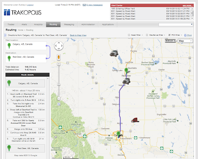
Our company, CAN Telematics, helps oil and gas companies address these challenges with solutions that track their assets, operating status, maintenance history, financial information and more. For example, one device monitors a well pump or a generator to sense the presence of certain gases or poll for other engine data. Another, mounted in a truck, logs location, speed, acceleration and braking habits. A third provides an “SOS” button for remote workers. Some devices incorporate accelerometers to detect falls or lack of movement.

The data is collected by GPS-equipped monitoring and sensing devices, then stored in the cloud. Our solution is based on Google Maps and retrieves data from Google Maps Engine, offering a familiar interface for our users as well as huge scalability. We also save our customers time and money by making information more accessible, and immediately meaningful. This video about Trakopolis shows how the sensing devices and maps work together to help companies track their assets and related data.

The benefits to companies are significant, starting with cost savings. They can add their privately built roads to the public roads in Google Maps, so it’s easier for them to determine which truck is closest to a facility that needs assistance. The maps also enable more efficient routing, saving time and fuel. These companies can also earn rebates on fuel taxes by easily determining the portion of their trucks’ travel that occurs on private roads -- with a fraction of the tedious, error-prone, manual record-keeping effort formerly required.
Driver’s history plotted on Can Telematics’  Trakopolis map interface. Dispatchers can enable Geofencing capabilities to  receive alerts when certain assets enter or leave an area.
Even more savings can come from tracking average speeds and driving habits: once monitoring begins, truck drivers tend to slow down and drive more carefully, so there’s a big safety benefit along with fuel and vehicle maintenance savings.

Our overall goal is an easier, more efficient and cost-effective way for far-flung companies to keep track of their extremely valuable assets. As we deploy our solutions to other continents and other industries, Google Maps is the natural choice for delivering critical information to the people who need it.

Posted:


Today, we live in a world where businesses are generating large amounts of real-time data from web applications that serve millions of users, online sales transactions, or customer activity created by an explosion of connected devices. Being able to react quickly to changes in the data being generated is critical to remain competitive. At the same time, businesses are gathering, storing and analyzing data -- sometimes 100s of gigabytes per day -- using legacy systems that struggle to keep up.

We built Google BigQuery to enable businesses to tackle this problem without having to invest in costly and complex infrastructure. And today this gets even easier with two key new features:

  • Real-time data streaming: you can now stream events row-by-row into BigQuery via a simple new API call. This enables you to store data as it comes in, rather than building and maintaining systems just to cache and upload in batches. The best part? The new data is available for querying instantaneously. Streaming ingestion is free for an introductory period until January 1st, 2014. After that it will be billed at a flat rate of 1 cent per 10,000 rows inserted. The existing batch-based ingestion will continue to be free.
  • Query portions of a table: you can now query a specific subset of a table using a simple new @<t> that we call a “table decorator” in your SQL statements. Though restricted to data inserted within the last 24 hours, this capability provides significant benefits beyond just cost efficiency -- for example, in conjunction with real-time data streaming, you can now use table decorators to monitor the last 30 minutes of user activity after a new change is pushed to your application.


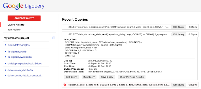
In addition to these features, we’ve also expanded BigQuery’s window functions to include SUM and COUNT -- statistical capabilities that many customers have asked for -- as well as regular analytic functions for calculating Correlation and Standard Deviation.

And to make the entire querying experience smoother, the BigQuery user interface has also received numerous productivity-enhancing updates. These include an expanding information panel when clicking on a query, as well as action buttons at the bottom of the query box to make it easier to edit, run, save, and show results.

You can get details about these new capabilities and examples from our Developer Blog and in our updated product documentation.

Whether it’s for capturing streams of application event logging or real-time user behavior analysis, we can’t wait to hear how you’re using BigQuery’s new features. And we hope you’ll share with our community via the #BigQuery tag on Google+.

Posted:


No wonder the customers of Speedway Motors love the retailer so much. The world’s largest manufacturer of specialty hot-rodding and racing products is using Google Search Appliance (GSA) to help car-racing fanatics quickly find and buy the hard-to-find parts they need from among thousands of items. Fast, relevant search creates loyal customers, including a handful who have been getting their parts from Speedway Motors for more than 30 years.

In our upcoming Hangout On Air with Speedway Motors - taking place Thursday, September 19th at 10 a.m. PT - you can hear Chris Chance, Speedway’s Director of IT, chat with Joe Davidoff, North American Sales Manager for Google Commerce Search. Also, Dwayne Remekie, Practice Director for enterprise solutions consultant GroupBy, will show a demo of GroupBy's product that uses Google’s relevance model to provide a best-in-class merchandising tool that integrates with GSA.

Chris and Joe will talk about the role that Google Search Appliance plays in the Speedway customer service story, and Chris will also share his insights on these questions:

  • How has better search helped Speedway increase conversions by 45%, and boost search revenue by 116%?
  • Why is search relevance so important to customers?
  • What search features help customers quickly find the products they need?
If you missed our previous Hangout On Air with Ocado, the world’s largest online grocer, you can catch up on the details.
RSVP for the Speedway Motors Hangout On Air, and take part in the Q&A by posting your questions on Google+ or Twitter using the the hashtag #GoneGoogle.

Posted:


(Cross-posted on the Official Google Blog)

Editor’s Note: Today’s guest blogger is Guy Willoughby, Executive Director of the HALO Trust, a UK-based nonprofit dedicated to landmine clearance in post-conflict areas. Hear how HALO is using Google Maps for Business to fight the war against mines, clearing more than 1.4 million landmines worldwide.

When conflicts end, making communities safe and livable often means removing dangerous remnants of war. “Getting mines out of the ground, for good,” as we say at the HALO Trust, has been our mission over the last 25 years. We work in more than a dozen countries and regions across the globe, clearing landmines and other explosives, many of which have been buried underground. While we’ve been in operation for almost three decades, there is still more to be done.

In Kosovo, where people are reclaiming their homeland after the conflict in 1999, we’re working in close cooperation with the government and local population to collect and share information about where mines are located. It’s a true community effort—farmers tell us where they’ve seen signs of mines and where accidents have occurred. It’s our job at the HALO Trust to take this data and make it usable, accessible, and visually compelling, so clearance becomes more efficient and happens faster.

One of our biggest challenges is keeping our field teams safe. We need easy-to-use tools that can help us find, map and clear hazardous areas without putting our operations at risk. Over the years, we’ve continuously improved our mine clearance techniques, including the deployment of Google Earth Pro.


Google Earth Pro makes it easier for the HALO team to do the dangerous and detailed work of finding and mapping at-risk areas. Because it’s based on the same technology as Google Maps and Earth, it’s easy for our teams to use and create maps without IT or GIS expertise. It’s a tool that is familiar to our employees and something they use in their daily lives, so we can start mapping right away.

The information we gather, including GPS references to landmines in the field, is imported into Earth Pro so that we can plot mine locations. We also use the incredibly detailed satellite imagery in Google Earth to identify and map hazardous areas. These high-resolution maps serve many people: from families who live near mines, to crews who clear them, and donors and other organizations that support us. When donors view the vivid interactive maps of our project areas—with mines so close to schools, farms, and houses—they understand why the HALO Trust’s work is so critical.

Learn more about HALO's work in Kosovo.
Accurate maps from Google Earth Pro mean safer working conditions for our local teams, and faster progress toward our goals. In Kosovo alone, we’ve removed thousands of landmines, cluster munitions and other explosives. And with the help of Google’s mapping tools and our donors, we’ll be able to declare the country mine-free.

Posted:


Editor's note: Today’s guest blogger is Benito Martínez, Senior Manager of Online Marketing at TIM Brasil. TIM is Brazil’s second largest telecom provider and has 1,800 stores and sales points located in different states around the country. See what other organizations that have gone Google have to say.


In August 2012, Brazil's National Telecommunications Agency (Anatel) demanded Brazil's national service providers to improve the quality of service and support for mobile phone customers. We responded by developing a three-year action plan funded with R$9,5 billion. In order to communicate the plan to customers and society, we designed a mapping service to reinforce the transparency and allow over to 70 million customers to keep track of our services.

We chose the Google Maps API and Google Maps Engine for this mapping project, because they would provide our workers and customers with a familiar service, a very easy and understandable user experience, and a manageable tool to monitor and update all the information regarding the coverage of our services. Using Google Maps, we can show the location of all the company’s antennas and WiFi Hotspots, so both TIM and our clients can locate our services. We can also display where there is 2G, 3G or 4G coverage. The map details the spots that are covered by the company, as well as those where there is no coverage, and informs transparently clients on the current and future activities like antennas installed recently and those that will be installed in the future.

Since deploying these tools three months ago, we’ve been impressed with the results. We’ve increased the number of visits to our web site from 500 visits per month to over 300,000 queries on the Google mapping tools, showing the increase in customers searching for the coverage range and services we are providing them in their respective areas. We update our data monthly, so we expect this number to grow as we add more and more information. This project also generated a tighter integration between the different areas of the company. For example, the marketing and network technical departments are now working together cooperatively to offer richer information about the service to ensure the constant flow of information for our customers.


We also developed a smartphone app which provides consumers fast access to all the services that are available online. This mobile app offers more customers the tools available from our “Open Doors” website on their smartphones and tablets. We are using Android OS as one of the main development platforms due to the widespread availability of Android smartphones in Brazil.

In the future, we plan to expand the Google Maps usage in our CRM initiatives in order to communicate in a more personalized way with our customer base by offering segmented maps. Overall, we’ve seen very positive benefits from adopting Google Maps Engine and the Google Maps API.

Posted:


(Cross-posted on the Google Chrome Blog)

Chromebooks were designed to make computers faster, simpler, safer and much more affordable for everyone. Over the past year, with the launch of Chromebooks by a number of our partners for as low as $199, they have become the go-to laptop for many people. We’re pleased to see consumers, schools and businesses react positively to Chromebooks. Research firm NPD says Chromebooks represent 20-25% of the $300-or-less computer segment. In education, more than 5,000 schools have deployed Chromebooks for their students, representing more than 20% of school districts in the US.

Together with our hardware partners, we’ve been working on expanding the Chromebook family. Intel, who has been with us on this journey from day one, unveiled a new lineup of Chromebooks today based on the Haswell microarchitecture at the Intel Developer Forum in San Francisco. Intel’s latest processors sip less power to improve battery life by more than 2X over previous generations, while offering increased performance. This means these new Chromebooks last almost all day so you can focus on getting things done.


Over the coming months, you’ll see Chromebooks from multiple device manufacturers. These include newly designed Chromebooks from Acer and HP, as well as new entrants ASUS and Toshiba.
Across the new lineup, the devices offer superb battery life and a variety of new designs—from a light and portable Acer Chromebook, to the large display on the HP Chromebook14, which comes in various colors; from the versatility and portability of the Toshiba Chromebook, to the ASUS Chromebox, suitable anywhere you need a computer. With today’s announcement, now six of the top laptop manufacturers are offering Chromebooks.

It’s been amazing to see the broadening of the Chromebook spectrum and we look forward to continued advances in both the hardware and software. Now more than ever, a new Chromebook truly offers something for everyone.

Posted:


(Cross-posted on the Official Google Canada Blog)

Last week all across Canada, students started a new school year. Educators everywhere have been getting ready for that first bell to ring and for classrooms to fill up. In the spirit of kicking off a new year, we talked with teachers in several provinces who are empowering their students with Chromebooks and Google Apps. We discovered some really inspiring work going on, so we’re sharing a few of our favorite stories here with you.

Grade four students Gabriel and Emily in Edmonton work on their e-portfolio sites.
Photo credit: Edmonton Public Schools
Bill MacKenzie is an Information Communication Technology Consultant for the Upper Grand District School Board just outside Toronto. He first introduced Chromebooks and Google Apps to the district’s 34,000 students two years ago. In deciding between platforms, MacKenzie noted, “What’s different about Google is the collaborative piece. More than one student can work on a project at the same time and share their work with others in the classroom or across the globe. That’s an absolute game changer for us.” Currently, 4,000 shared Chromebooks are deployed throughout the district’s elementary, secondary, and high schools.

IT Director Philippe Lemieux was equally excited about bringing Google Apps and Chromebooks to his French-language public school district in Canada. This fall, all 13,000 students and 38 schools in the Eastern Ontario French Public School Board will be using Google Apps, and over 3,000 Chromebooks will be deployed across the wide-spread school board. While Lemieux was blown away by the potential in Google’s collaboration platform, IT staff benefit too: “Chromebooks are the only thing I can deploy massively without adding staff, without adding resources, without a lot of preparation. It is so easy. We purchase them, we enroll them in our domain, and give them to schools.”

To the west, in Edmonton, Alberta, more than 96,000 students, staff, and teachers are using Chromebooks and Google Apps. Terry Korte coordinates Technology Integration Planning Services for Edmonton Public Schools, where dedicated labs have been replaced by class sets of Chromebooks. Students have access to the technology right in the classroom, and “they’re writing more, editing more, accepting feedback more. Google Apps is a real leveling force across our district.”

We’re excited about what educators in Canada are doing with Google technology and can’t wait to share more about their and others’ work with you throughout this school year.

To learn more about Chromebooks you can contact the Google Education Team through our website. Or learn from some educators: Scott Monahan and Jim Jamieson are Digital Literacy Resource Teachers for the York Region District School Board in Ontario. As part of their board's roll out of Google Apps for Education to over 120,000 users, the two have organized a “Google Camp” for more than 500 of their teachers next month; join their G+ community to get in on the conversation.

Posted:


Attending our new Hangout On Air series with the world’s most innovative retailers is like having a super-smart business consultant sitting at your desk. Over the next several weeks, we’ll be talking to companies like Ocado, the world’s largest online-only grocer, and Speedway Motors, an online retailer of street racing products, to find out how they’re ramping up business productivity and winning the love of their customers.

Our first Hangout features Ocado on Thursday, September 12, at 8 a.m. PT, with Paul Clarke, Ocado’s Director of Technology, and Rhonda Stites, Head of Industry for Google Enterprise. Ocado offers same-day delivery of groceries to UK households and ships more than 150,000 orders per week. They use Google Apps for Business, Google Cloud Platform, and Google Maps for Business to stay agile and collaborate on projects, easily create and test new apps, and inform customers about shipping and delivery.


Paul will cover these questions:
  • How is Ocado using technology to drive innovation and business productivity?
  • How do you manage and use all the data you’re collecting to make better business decisions and direct strategy?
  • What are you doing to create amazing customer service?
RSVP for the Hangout On Air – and post your questions on Google+ or Twitter using the hashtag #OcadoGoneGoogle since there will be opportunity for Q&A.

Posted:

(Cross-posted on the Google Drive blog.)

From classroom pop quizzes to RSVPs for your team offsite, you can use Google Forms in tons of different ways -- which is why it's important to be able to customize each form to fit your needs. Starting today, you’ll be able to take advantage of four new features to create your perfect form: progress bars, data validation, embedded YouTube videos, and custom messages.

Guide respondents through your survey with a progress bar
Sometimes it’s helpful to give respondents a sense of how much of a survey still needs to be completed, and now you can by turning on a progress bar in your form.
To turn it on, just check the progress bar box in the Form Settings tab.
Get results the way you want them with data validation
Let’s say you’re using Forms to collect sign ups for an email newsletter. With data validation, you can now ensure that the email addresses are formatted correctly, and consequently avoid those unpleasant bounce-back messages.

To get started, create a new Text question in Forms, then click on the Data validation tab. Click the checkbox and select “Text,” then “Email address,” and voila, the survey taker will see an error message if they don’t enter an email address.
You can also set up data validation for maximum character count, numbers, zip codes, and more.

Embed YouTube videos
You can now embed a YouTube video right inside a form -- perfect if you want to get feedback or ask questions about a video.

This works really well for quizzes in class, especially if paired with data validation and the progress bar. Embed a video and then use data validation to give hints when students enter incorrect answers, and add a progress bar so they know how far along they are in the quiz.
Add a custom message to closed forms
Sometimes when a form is closed, you still want to make information available for respondents who weren’t able to complete it in time.
After you’ve switched your form to “Not accepting responses,” you can now add your own message and instructions for follow up.


Posted:


Editor's note: Today’s guest blogger is Tyler Carr, Production Manager at Leon Speakers. The company is headquartered in Ann Arbor, Michigan and specializes in high-performance, on-wall loudspeakers. Find more info about Chromebooks and see what other organizations that have gone Google have to say.

Fifteen years ago, a few art and music graduates from the University of Michigan founded Leon Speakers because of their passion for art and audio, technology and design. Leon Speakers now has roughly 40 employees and we meticulously handcraft a full range of high-fidelity, elegant loudspeakers.

We devote the majority of our time to building great audio experiences, and so we have spent less time optimizing our processes. Although we had developed a custom software platform to manage orders, we were still using paper notes and Microsoft Excel spreadsheets for much of our information exchange. Our production technicians on the floor created manual checklists to track projects and, at night, I’d print out dozens of updated lists for the next day’s tasks. Even though we were able to produce custom speakers for hundreds of customers at breakneck speeds, for a cutting-edge audio company, our processes were pretty laborious and inefficient. And, as a rapidly growing company (it's our third year on the Inc. 500|5000 List), I knew we had to transform our approach to the manufacturing process.

We decided to make a leap into the future, rather than taking a few small steps. Our requirements were specialized. We’re an assembly manufacturing shop – there is a lot of wood being cut and dust everywhere – and we have skilled craftsmen who may not have a lot of computer training. We knew that from a productivity standpoint, Google Apps would fit our needs. We would no longer have to pay constant licensing costs and wait for upgrades. Instead, we would get continual innovation and have virtually no upkeep. Google Drive would also be a great way to store and share our large 3D design files, which we typically create in CAD programs like SolidWorks. Plus, I could put the entire build schedule on a shared spreadsheet that could be updated in real time by all of my employees.

Then came the question of devices. We looked at Panasonic Toughbooks and several other hardware options, but couldn’t justify the upfront costs and ongoing maintenance expense. Then we found Chromebooks. They were the perfect way for us to inexpensively deploy fast and easy-to-use laptops on the floor. We bought dozens of Chromebooks for our employees to share. It was a third of what we would pay for buying everyone an individual laptop due to the easy sharability factor.

The startup, resume and processing speed of Chromebooks has been phenomenal. It’s very easy for technicians to view their tasks and get their jobs done faster by accessing their lists and tasks in Google Drive. The Chromebook Management Console allows us to push out our corporate websites and apps to the Chromebook app launcher, making it a no-brainer for anyone on staff to pull up job-relevant information. Not to mention the savings in paper and printing costs: everything is now virtual, and if I need to change something based on a customer request, it’s as easy as hitting Enter.

As a production manager, I don't want to spend my time managing IT. Because Google Apps and Chromebooks are so easy to manage, I can spend less time as an IT administrator and more time doing what I love.

Posted:


Editor's note: In today’s guest blog post Daniele Schillaci talks about Toyota's Touch 2 with Go technology, launching in January 2014. Hear how the company is bringing premium map features from Google to drivers.

At Toyota, our vision is to change the future of mobility, helping people get around in ways that can enrich their lives. Over the years, we’ve built our brand on the foundation of quality, safety and affordability. As we roll-out new in-car technologies, we’re working to maintain these core values, as well as exceed expectations for our brand.

Starting in January 2014, Toyota drivers will have access to Google Street View and Panoramio via the Toyota Touch 2 with Go connected technology. The newest in-dash system provides direct access to Google-sourced imagery and geo-tagged photos, allowing drivers to see a realistic view of their surroundings on a map.

By having access to street-level imagery of a final destination, such as a store entrance or a parking lot, Touch 2 with Go users can experience easier door-to-door navigation. Additionally, Google imagery and user-generated photos will be displayed on Toyota’s second generation Touch unit, which has four times the number of pixels and screen sizes of up to 8 inches. This brings strikingly clear visual-based cues to users within seconds.

While the latest in-car technologies have traditionally been available in luxury vehicles, we’re bringing best-in-class connectivity to our mainstream brands. We’re giving Toyota owners a one-year, free subscription to the Touch 2 with Go infotainment system, allowing drivers to access Google Street View and Panoramio, plus real time traffic, weather, parking and fuel prices - all from a bluetooth connection from inside their cars.

We’re excited to bring premium map features from Google to even more drivers and their passengers. Not only will this guide them to nearby places, it’s a step forward for raising expectations around Toyota innovation and the future of mobility.

Posted:


Editor's note: Our guest blogger this week is Daniel Thommen, Managing Director of LOSTnFOUND AG, a Swiss-based company that makes tracking systems for the transportation and health care industries. See what other companies that have gone Google have to say.

With 20 employees and offices in Germany, France, Switzerland and Poland, LOSTnFOUND sells telematics systems that enable companies to keep track of goods all the way from the warehouse to the store using GPS technology. Our company was the first to develop this technology for the transportation industry in 2009 and is one of the leading companies using this technology in Europe. We realized these systems could be used not just to help track packages, but also to find people who are lost and need help. So LOSTnFOUND used Google Maps and Geolocation APIs to develop a product called guard2me that helps people keep track of their loved ones who suffer from Alzheimer’s Disease.

Millions of people around the world every year are diagnosed with Alzheimer’s, which is characterized by dementia. Getting lost is a common problem for people with the disease because their memory is impaired and they easily get confused and wander off. Patients can quickly find themselves in dangerous situations and have no idea what their address is or how to contact their care provider or family.

guard2me has a GPS sensor embedded in a watch worn around the patient’s wrist to track the location of the patient at all times, allowing care providers and family members to locate a patient who is lost or in an emergency situation. The GPS is complemented by an innovative Cell-Locate technology which triangulates signals to determine positions when satellite coverage is not available. So guard2me does not lose coverage when used indoors. GSM availability keeps it ‘live’ when a GPS signal is out of range. This means that the patient’s location can be pinpointed even within a building.

Care providers and family members can see exactly where the patient is on an online map, as well as access the Web-based system. Care providers looking after multiple patients can use an iOS mobile app to see where each patient is at any time.

There is a huge need for digital aids that can help medical providers monitor patients remotely, respond faster to emergencies and provide more attention to patients without interfering with their lifestyle and activities. guard2me helps keep Alzheimer’s patients safe from harm and provides loved ones peace of mind that if a family member gets lost or falls, help will be on the way quickly. This allows patients to maintain their independence and freedom, rather than forcing them into care facilities and 24-hour care. And that makes everyone happier.