Maranhão
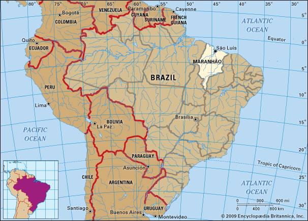
Maranhão, estado (state) of northern Brazil, situated south of the Equator and southeast of the Amazon River basin. About two-thirds of its area consists of a low heavily wooded region bordered by the Atlantic Ocean to the north. To the east and southeast lies Piauí state, and to the west lie the states of Tocantins and Pará.
The higher plateaus in the southern section of the state are northeastern extensions of the Brazilian Highlands. The highest point, the Serra da Cinta, is 4,373 feet (1,333 metres) in elevation. From these highlands a number of river systems run generally northeastward into the Atlantic. Several of them form a delta region around the capital city of São Luís, which stands on an island. The delta is bounded to the west by dense mangrove forests and to the east by areas of quicksand. The rivers in the state are navigable for much of their course, cutting through arable soils that support farming and cattle raising, the economic mainstays of Maranhão. The climate is hot and moist. There is a wet and a relatively dry season but never a rainless one.
The Tupinambá people inhabited the Maranhão region when Europeans first explored the coasts in 1500 and when the region was included in land grants, known as captaincies, made by the Portuguese crown in 1534. In the decades that followed, rival European powers attempted to take possession of the territory. The first settlement was established by the French, in 1594; later, in 1612, they also founded a colony on São Luís Island. The French were expelled by the Portuguese in 1615, but the Dutch succeeded in holding São Luís from 1641 to 1644.
In 1621 Maranhão and adjoining regions were united as the Estado do Maranhão, which remained independent of the southern captaincies and of Portuguese colonial administration until 1774, when the territory was formally made part of the Portuguese colony of Brazil. In 1823 Maranhão adhered to the newly independent empire of Brazil and, in 1889, to the newly proclaimed republic.
Maranhão was settled mainly by Jesuit missionaries, who introduced Roman Catholicism to the Tupinambás, along with the pattern of agriculture and cattle-raising that continues to characterize the local economy. The people of Maranhão represent a blend of Tupinambás, Europeans (mainly Portuguese), and the descendants of African slaves, the latter being numerically predominant. There has been considerable racial intermarriage between these groups through the centuries, though in interior regions descendants of the original Indian population, known as caboclos, remain. Portuguese is the main written and spoken language, but it has been enriched by Indigenous languages, just as Portuguese culture has been supplemented by local folklore. Most of the population is Catholic.
Most of Maranhão is an economically underdeveloped region—one of the least urbanized areas in Brazil—and is dependent largely on agriculture and cattle raising. Palm oils from the babassu nut are a major export item, as is rice. Fishing supports a significant number of coastal inhabitants. By the end of the 20th century, Maranhão had experienced a high rate of industrial growth. Important industries include food processing, steel manufacturing, and aluminum smelting, centered in São Luís. There are bauxite deposits on Turiaƈu Island, and petroleum discoveries have been made in the interior near the Tocantins border and in the northern part of the state. A hydroelectric facility was completed at Boa Esperanƈa in 1970.
Itaqui Quay on São Luís Island is one of several modern shipping points on Maranhão’s coasts, and the navigable river system permits extensive shipment from ports deep in the interior. A railway 250 miles (400 km) long links São Luís with Teresina, the capital of Piauí state; a 554-mile (892-km) line joins São Luís with the state’s central and western agricultural regions and with the mineral-producing Carajás region of Pará state. The road network is only partially paved. There are several commercial airports, of which the international airport at São Luís is by far the most important.
Medical facilities and health standards are relatively good in urban areas. Occasional outbreaks of tropical disease rarely reach epidemic proportions. The state supports primary, secondary, and university education, in addition to which there are independent colleges, a number of technical institutes, and private educational institutions at lower levels.
Cultural institutions include the Historical and Artistic Museum of Maranhão and the Maranhão Historical and Geographical Institute. The state’s best-known figures include writer Antônio Gonçalves Dias, a poet in the Romantic tradition versed in Maranhense lore whose “Song of Exile” is renowned, and former Brazilian president José Sarney. Area 128,179 square miles (331,983 square km). Pop. (2022) 6,800,605.


