Landsat Next Defined

Landsat Next Defined

Landsat Next is on the horizon—the new mission will not only ensure continuity of the longest space-based record of Earth’s land surface, it will fundamentally transform the breadth and depth of actionable information freely available to end users. Take a look at the new capabilities that will define the next Landsat mission.

Read More »
Landsat Next Defined

Landsat Next Defined

Landsat Next is on the horizon—the new mission will not only ensure continuity of the longest space-based record of Earth’s land surface, it will fundamentally transform the breadth and depth of actionable information freely available to end users. Take a look at the new capabilities that will define the next Landsat mission.

Read More »

“LANDFIRE is the only complete, nationally consistent collection of spatial resource datasets with an ecological foundation.”


“Many people have no idea how Earth imagery has improved their daily lives as it has become integrated into modern technologies. Like GPS and weather data, information from Landsat is woven into the fabric of our economy and society.”


“[T]he pivotal aspect of the Landsat mission is the acquisition and curation of the most comprehensive and longest uninterrupted cross-calibrated EO data record ever gathered, with ensured continuity, and with ongoing efforts to consistently reprocess the entire image archive to incorporate cutting-edge advances in data preprocessing, which are then distributed as ‘collections’.”


“Land cover is fundamental for a plethora of applications. Approaches using #Landsat time series have been transformative.”


“The Landsat series of satellites is a cornerstone of our Earth observing capability. The world relies on Landsat data to detect and measure land cover/land use change, the health of ecosystems, and water availability.”


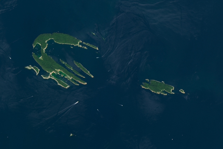
“Those are the Islands of the Four Mountains… The Landsat image shows them on June 8, 2013… One of the things I love about science is how it gives us perspective.”


“Data from Landsat and the MODIS sensor are well-suited to help people make informed policy decisions about ecosystem health, water management, agriculture and much more.”


“We use Landsat 8 to document glacier velocity patterns on a mountain-range-wide scale. Mapping glacier velocity is facilitated by Landsat’s high radiometric resolution and precise geolocation.”


“Without Landsat it would be essentially impossible to get good Ground Control Point locations from other sources.”


“What we’re able to do now is track the flow of the world’s ice from pole to pole and on every continent.”


“The economic and scientific benefits to the United States of Landsat imagery far exceed the investment in the system.”


“This portal harnesses more than 37,000 images from Landsat archives, dating back to the early 1970s, to track changes in outlet glaciers over time.”


“We have a globally consistent, locally relevant map product that can be used in a variety of applications: estimating emissions from deforestation, modeling biodiversity, assessing protected areas, and studying forest and human health. We plan to move our record forward and backward where Landsat has a sufficiently rich archive of data.”


“It’s being able to go back in time for the same location, with the same program, that’s given us a tremendous amount of really valuable information… With Landsat we can do that because the archive is so rich.”


“Our new interface specifically uses Landsat to track flow velocity fields of Greenland’s outlet glaciers and how they have changed over time.”


“Landsat, with its five-decade record of robust collection, calibration and archiving, and its longstanding service as a global reference to cross-calibrate other missions, improves not only the quality of those systems but the overall quality of the global ‘system of systems’.”


“By seeing in electromagnetic increments beyond the normal range of human vision, Landsat revealed whole new worlds hidden within the folds of a familiar world we thought we knew so well.”


“This is really an exciting time for Landsat polar science, a new era so to speak. With Landsat Next on the horizon, the LEAP special request program and its observations of Earth’s polar regions—and the global cryospheric state more broadly—can only be expected to grow in impact and relevance.”


“Many of our customers’ work couldn’t be done without Landsat.”


“Landsat data are essential for monitoring long-term changes of Earth’s ecosystems.”


“If you don’t do the calibration right, you can’t do anything else.”


“This [Google Earth] update was made possible in a large part thanks to the Landsat program and its commitment to free and accessible open data. Landsat, a joint program of the USGS and NASA, has observed the Earth continuously from 1972 to the present day and offers a wealth of information on the changes to the Earth’s surface over time.”


“Since the first in the line of Landsat craft entered orbit in 1972, this satellite program has proven valuable to the economy of the United States.”


Landsat 9 bw
Landsat 9 bw
Landsat 9 bw

The NASA/USGS Landsat Program provides the longest continuous space-based record of Earth’s land in existence. Landsat data give us information essential for making informed decisions about Earth’s resources and environment.